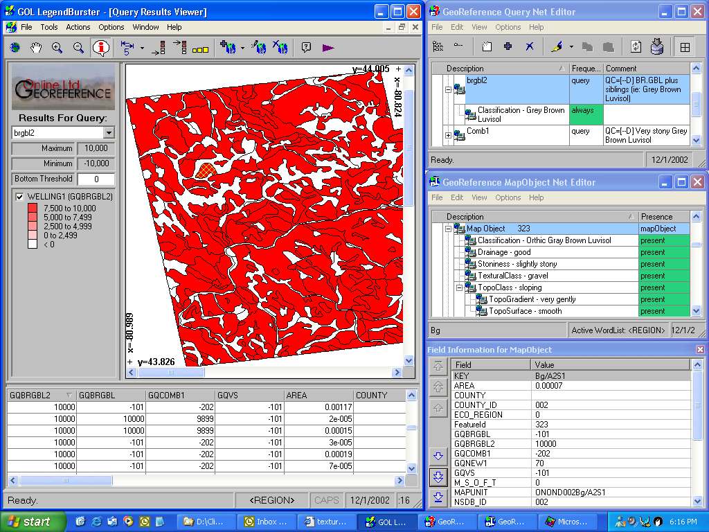
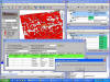
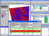
| (1)
The map window shows the result of a query requesting all polygons labeled
as "Brunisolic Grey Brown Luvisols". The LegendBurster query,
and its documentation, appear in the top right window, and the semantic net
describing the selected polygon (yellow hashing) in the middle right window.
The shapefile attribute table appears below the map, with the query scores
in the leftmost column, in descending order. The row corresponding to
the selected polygon appears in blue. The bottom right window also
displays the shapefile attributes of the selected polygon, but in a vertical
layout, the order of which can be adjusted to suit the interpretive work
under way at any particular time. |
 |
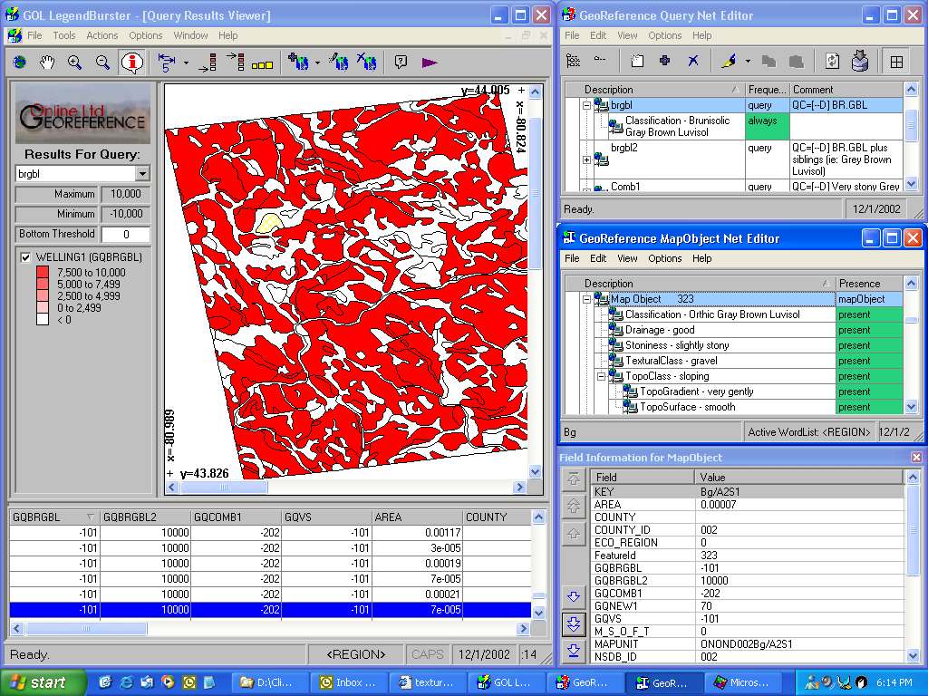
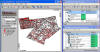
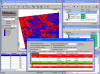
| (2)
The map window now shows the results of a query requesting all polygons
labeled as "Grey Brown Luvisols". Note that the selected
polygon, which is an "Orthic Gray Brown Luvisol" was not included in the
solution set to the previous query. LegendBurster's access to the soil
classification hierarchy enables it to include Orthic, Brunicolic and all
the other kinds of Grey Brown Luvisols in the solution set to the posted
query. |
 |
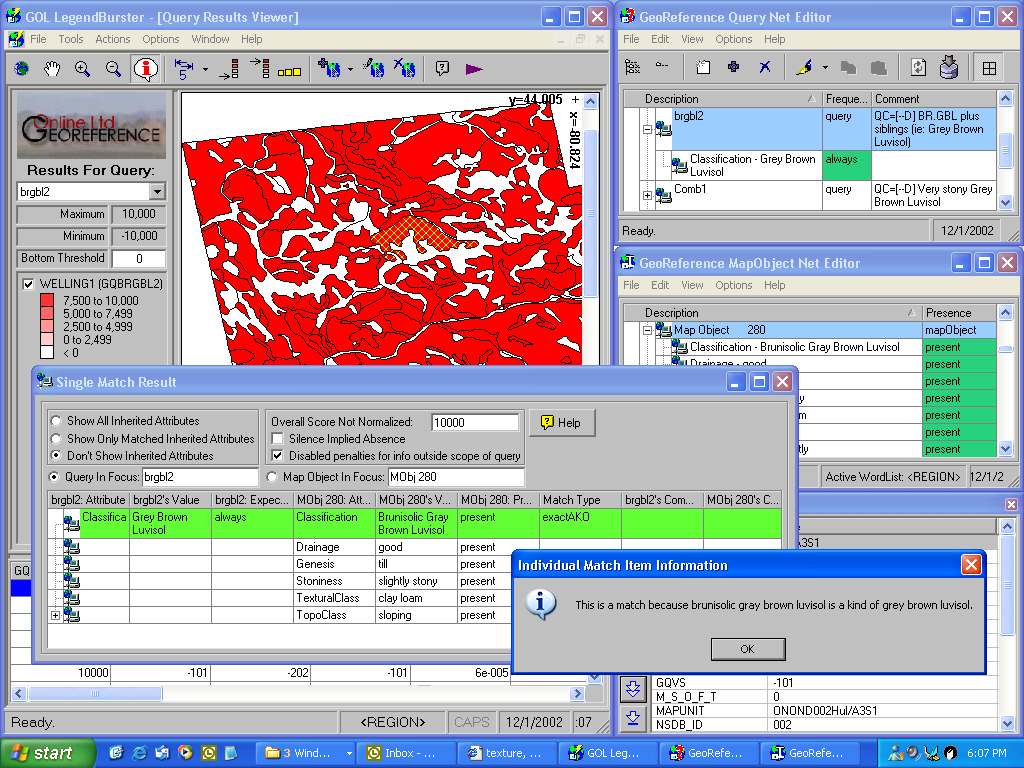
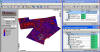
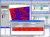
| (3)
Clicking on the "Compare" button (purple arrow) in the toolbar will
pop up a comparison of the query's attribute values and those of the
selected polygon, highlighting matching attributes in green, and conflicts,
as well as certain kinds of mismatch, in red. "Neutral" attributes appear in
white. The "Match Type" column in the pop-up identifies the
type of match or mismatch between attributes. When matches or
conflicts result from relationships in the classification/terminology
hierarchy, they are suffixed with "AKO" (= a kind of). An
explanation of the hierarchical relationship can be obtained by
double-clicking on the line containing an "AKO" match or conflict, as shown
in this example. |
 |
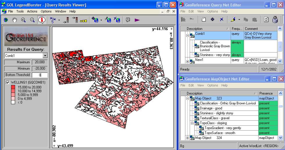
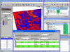
| (4)
This map shows the result of a query seeking "very stony brunisolic grey
brown luvisols". Three different classes are identified and
displayed by the single query: (1) Polygons which fully satisfy the
query (red); (2) Polygons which are either very stony or brunisolic
grey brown luvisols (pink); (3) Polygons which are neither (white).
|
 |
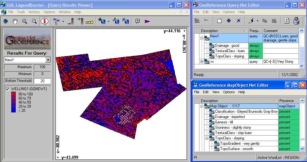
| (5)
This is the LegendBurster map resulting from a query with three different
kinds of attributes: drainage = "good"; textural class = "loam" and
topographic class = "sloping". Bright red polygons satisfy the
query completely - bright blue polygons have none of the
required attribute values. We examine these cases, as well as
intermediate matches to the query in the displays below. Maps like
this are essential to the evaluation of complex data sets, and the
exploratory data analysis that goes with such evaluations. Producing
such maps with "SQL-only" querying tools is a long process requiring
considerable SQL expertise. No SQL is required of the user in
LegendBurster. How LegendBurster queries work is explained in a
paper here.
|
Hi-Res map here |
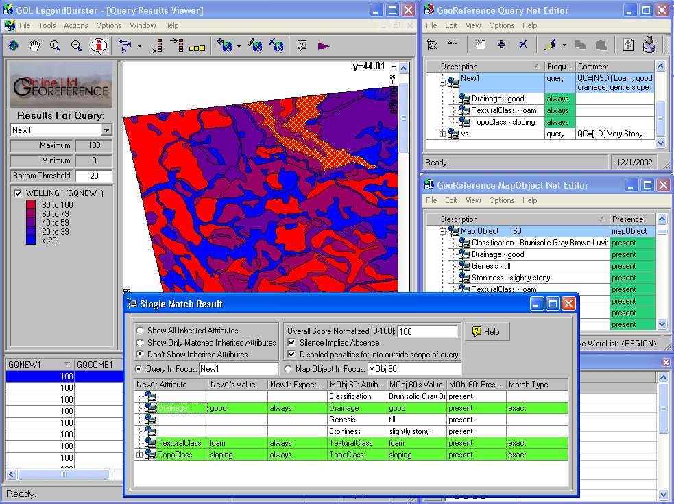
| (6)
This map illustrates a perfect match to the query discussed in (5)
above from the north-west corner of the Wellington map. A bright red
polygon has been selected (hashed in yellow), and its attributes have been
compared with the attributes of the query by clicking on the "Compare" tool
(purple arrow). It is clear from the comparison provided by
LegendBurster why the selected polygon has scored a maximum 100
normalised points against the query. To find out how LegendBurster
calculates matching scores, as well as the options available to the user,
please refer to the link in the box above. |
 |
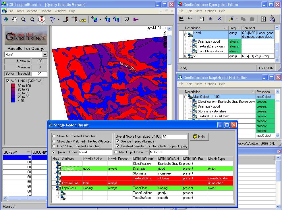
| (7)
This map of the same area as (6) illustrates a close-to-perfect match
with the query (dull red). Two of the three required attribute values
are present in the selected polygon, as shown by LegendBurster's "Compare"
function. The red lines highlight an unmatched attribute value in the
query, as well as an attribute of the same type, which has no match.
The latter is called a "mismatchextra" because it comes from a class
which is represented in the query, but does not conflict with it.
(Conflicts arise from an attribute value being present in one object and
absent from the object it is being compared with. LegendBurster users
are able to choose whether "silence implies absence". This
assumption can have a considerable influence on the outcome of many queries.
Whether it is an appropriate assumption depends on how the data was
prepared.) |
 |
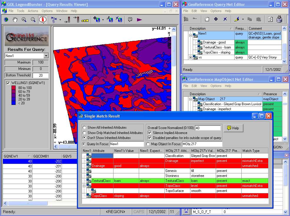
| (8)
From the same area of the map we have a dull blue polygon with a
far-from-perfect match with the query. The "Compare" feature
again provides the information on which the matching score was based.
While the examples shown in this and the previous two boxes do not involve
any "AKO" relationships (see Box 3 above), the reader can well
imagine how often these do occur during query resolution, and how useful the
"Compare" function is auditing query results which include them. |
 |
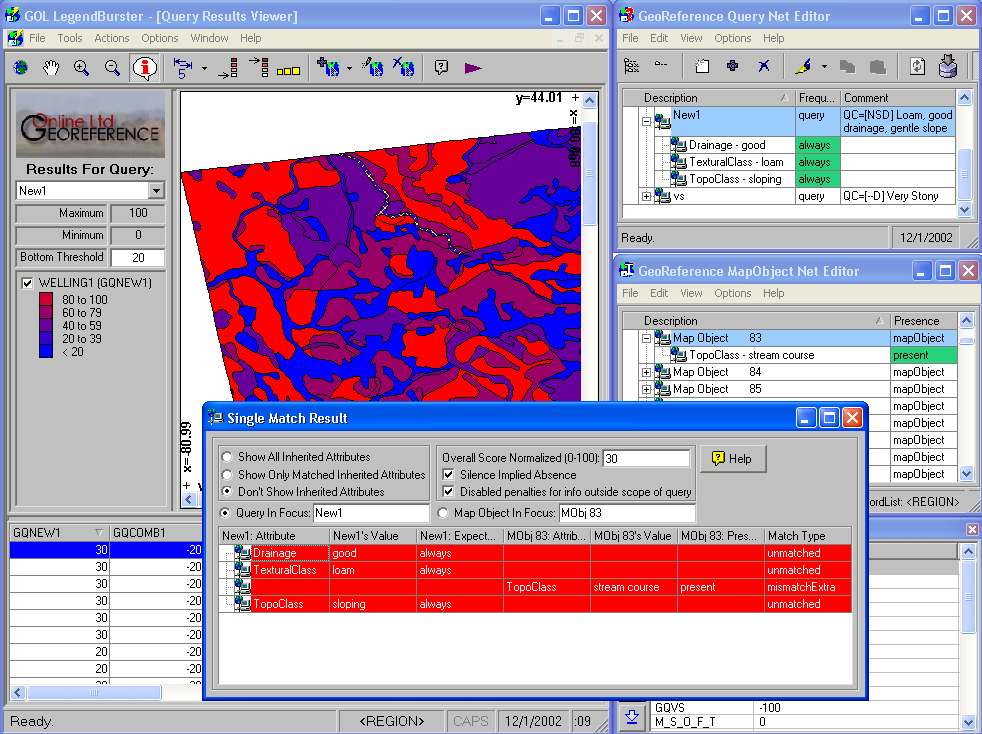
| (9) This example and the
next illustrate that useful insights may emerge from LegendBurster
query results even at the lower end of the scores against the query. Neither
the polygon selected in this example (a stream course), nor that in the next
(a large soil polygon) share any attribute values with the query. And
hence both score very poorly. But the soil polygon, with its "mismatching
extra" attributes receives a lower score than the stream course, for which
values of slope, drainage and textural class have not been reported.
Since they have not been reported, and since the "silence implies absence"
option had not been selected, LegendBurster assumes that they are unknown.
As a consequence, the polygon receives a slightly better score than if they
were known, and not matching, as in the case illustrated below. |
 |
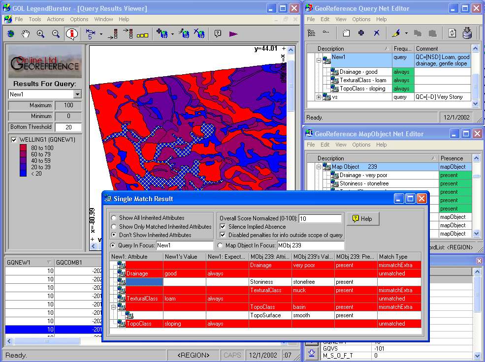
| (10) A soil polygon with a
complete absence of attribute values which match the query. As
a result it receives a very low score. The only polygons that have
scored lower than this one are those that have more than one soil-type in
the same polygon, and have therefore ended up with a larger number of "mismatchextra"
attribute values, which contribute to higher penalties. |
 |